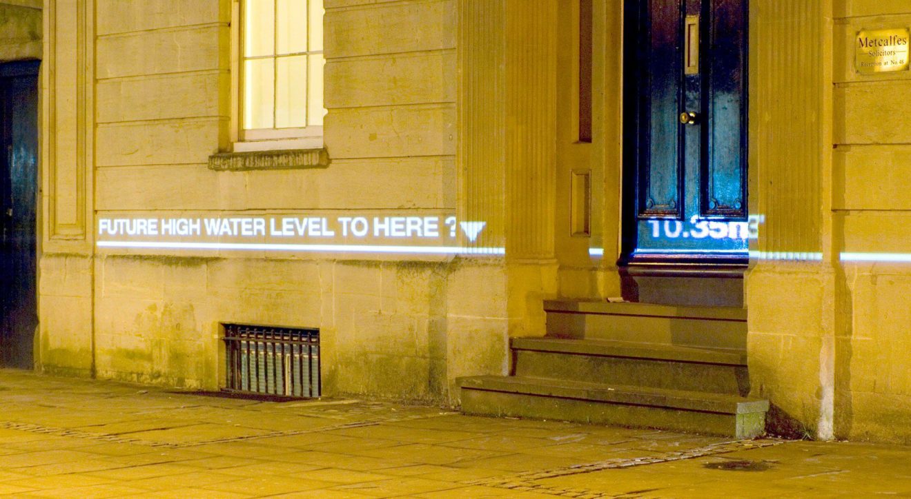
Watermarks 'Metcalfes', 2009. Image courtesy of Chris Bodle
Synopsis
Sea levels are rising due to climate change… but how much could they rise and how quickly? And how could this affect the world’s coastal cities?
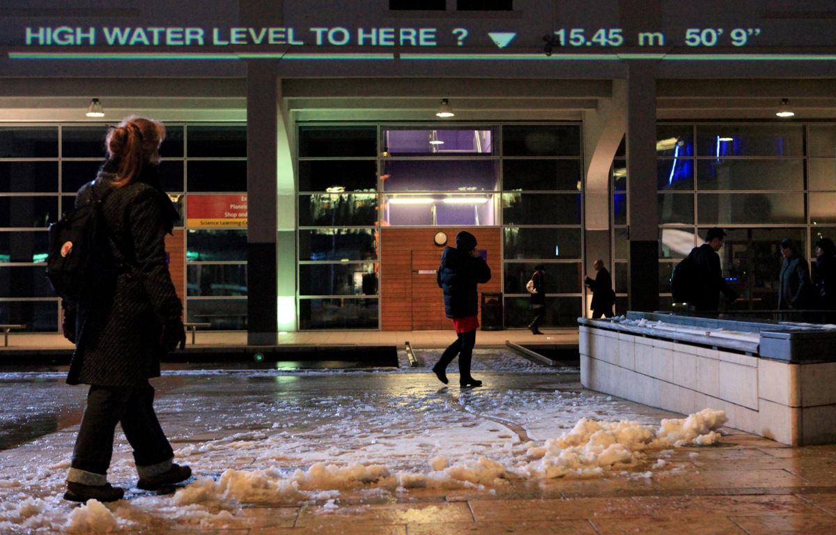
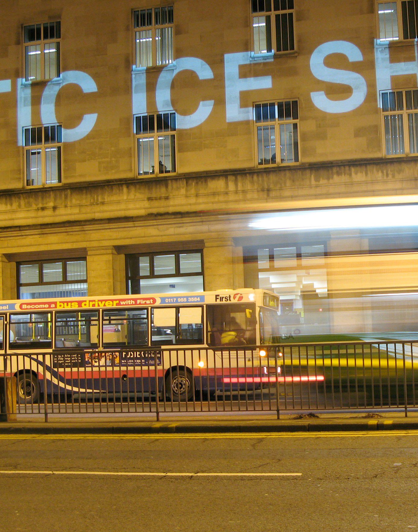
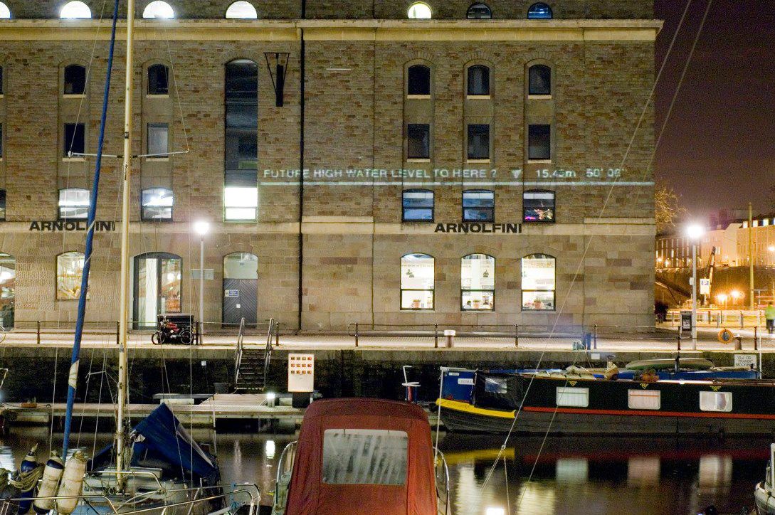
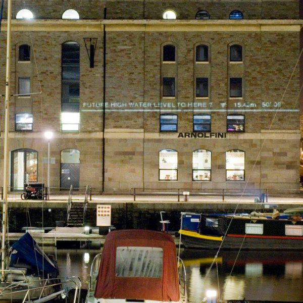
Watermarks is an ongoing public art project that explores these questions. Between 6th and 12th February 2009 a series of large-scale projections were displayed at sites across the centre of Bristol. Flood level marks were projected on to the facades of buildings, showing how high water levels could potentially rise if the sea were to inundate the city. By displaying these levels in real space, the project aimed to help the audience imagine the depth and extent of this potential future flooding – allowing us to measure the possible future water levels against ourselves in familiar environments.
Description
The Bristol projections, funded by Arts Council, England, were the first phase of Watermarks – further phases will extend the project to other cities in the UK and globally. The complexity and inherent uncertainty involved in predicting sea level rise means there is little consensus across the global scientific community as to how much sea levels could rise in the coming decades. The Watermarks project (Bristol) used current UK government predictions for the next century to set the key flood mark levels.
The project, however, also acknowledged uncertainty by exploring other, more extreme scenarios. Future phases of the project will use the latest sea level prediction data as it emerges – displaying a wide range of potential scenarios from across the scientific community. This project aims to act as a catalyst for debate and engagement. The future of our cities and landscapes and our responses to rising sea levels should not just left to scientists, politicians, engineers and the built environment professions, but emerge from as wide a base as possible with participation and involvement from all sections of the wider community. Ultimately the mitigation and adaptation measures will be social and cultural as much as scientific and technical.
Original Artistic Concept
The high water levels of major flood events have been marked out on buildings, walls, bridges and other structures throughout history. This proposed project picks up on this tradition. However, instead of marking actual floods at the time they occur, it uses the same image system to ‘mark’ the position of possible future floods. It is proposed that, ‘flood marks’ would be projected onto the side of buildings, walls and other structures using digital projectors. The positions of the projected flood marks are intended to be accurate in terms of the topography of the city. That is, the level marked represents the actual level the flood waters would reach in a real flood event. As well as being specific and accurate in terms of their height/position, they would also be based on real scientific projections of possible future flood scenarios.
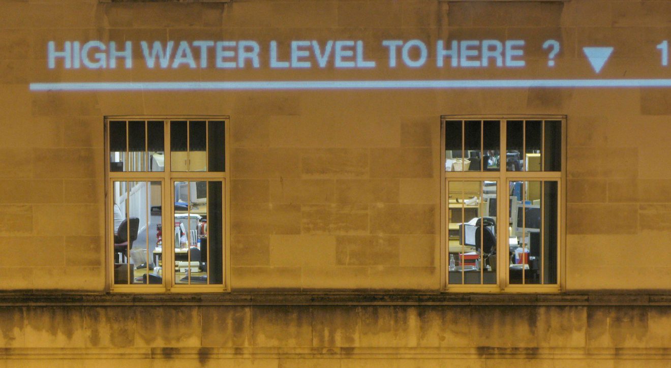
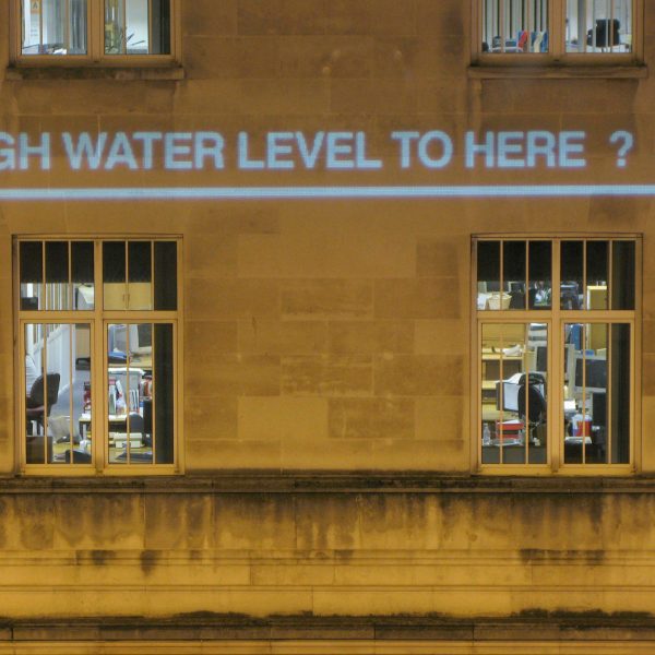
On a practical level, the use of projection allows the ‘marks’ to appear on any kind of surface, to be highly visible / luminous and to be displayed at height. This technique would necessitate projection from one side of a street (or other public space) to the other. Where traffic and passing people cut across the projected beams, fragments of text and strips of light would momentarily appear on clothing, skin and on the side of buses and cars. This dynamic relationship between the projected flood marks and the movement of people and vehicles through the city would strengthen the experience, piquing curiosity and allowing for a degree of interaction. Where the image is projected horizontally, at a low level, walking through the beam would become the equivalent of wading through the floodwaters.
It is conceived that the text accompanying each flood mark will be in multiple languages – each language being displayed for a time before being replaced by another. This not only reflects the multiplicity of languages spoken in the city but also the global nature of the phenomena described. The use of Bengali (Bangla), Mandarin Chinese and Dutch, for example, hint at how these countries would be affected. The cycling of the images will also include an invitation to engage in discussion. E.g. What do you think? www.watermarksproject.org. The accompanying website would form an important part of the project and provide a forum for discussion which it is hoped will be a crucial part of the work itself, extending the scope beyond the initial projected images. Exploration of the potential of a non web based discussion forum would also be explored.
The proposal aims to help an audience see, directly, possible future flood levels. This is intended to be a way of making some of the potential effects of climate change less abstract. To turn scientific data into a social cultural/experience that is played out in everyday, public places. Flood marks help us imagine the depth and extent of floods, to measure them against ourselves, to understand them in relation to the scale of our own bodies within familiar environments. We can see where the water level could come up to on a particular building and from this, imagine how these floods could affect other buildings, places and familiar objects, and consequently the impact they might have on our lives. It is hoped that by being accessible and by representing dramatic scenarios in familiar surroundings, these works would provide a catalyst for debate and discussion by a wide range of people.
Sea level projections and how they have been used
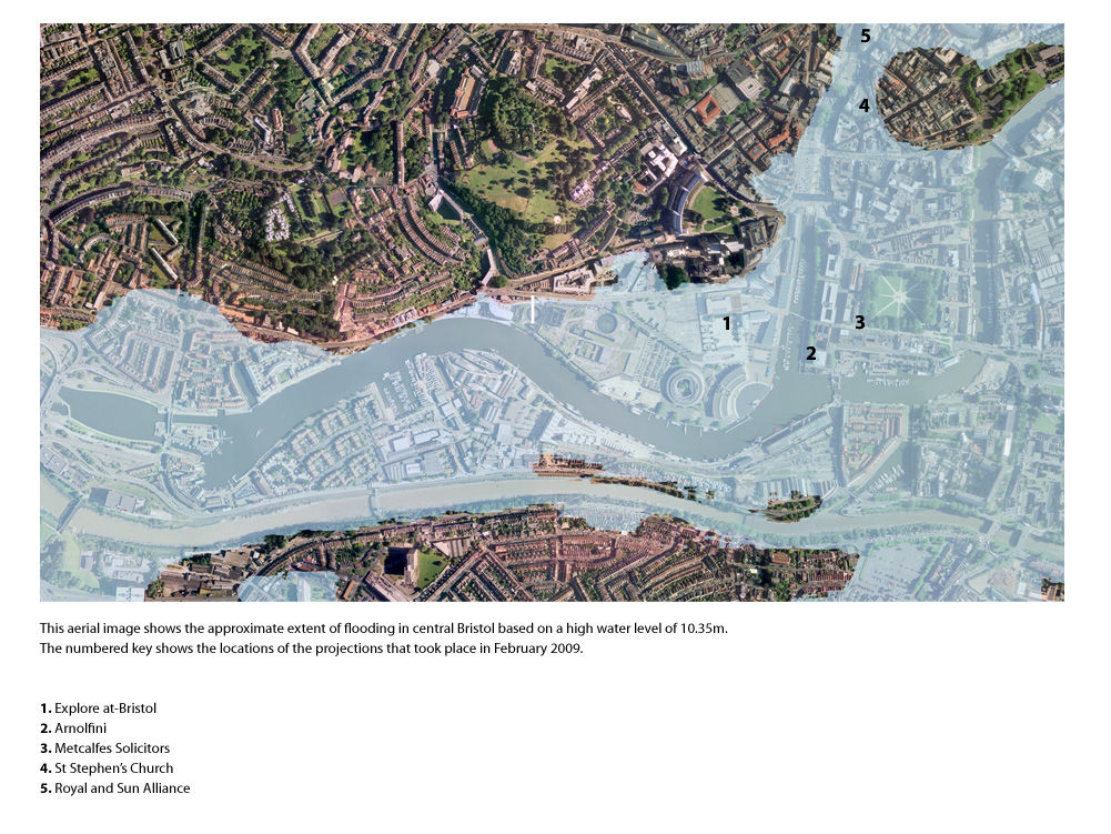
The sea level data used for Watermarks Bristol was based on the information available for the UK at the time. This data in turn was based on the UN Intergovernmental Panel on Climate Change (IPCC) projections. With the support of the Tyndall Centre for Climate Change Research, this information was applied specifically to Bristol. The levels used for Watermarks represented the projected combined effect of sea level rise, an extreme high tide and a storm surge for the year 2107. This combination amounts to a water level of 10.35m (33′ 11″) above the current mean sea level or approx 2m (6′ 6″) higher than the current average high tide. Using LIDAR height data for the city, this level was ‘mapped’ on to the buildings and the position and height of the projected images were set accordingly. Since Watermarks, Bristol, the latest official sea level projections for the UK have been updated and available at the UKCP09 website. The new projections put more emphasis on a range of probabilities, acknowledging a high level of uncertainty. The UKCP09 will be incorporated in to next phase of the project.
This project deals with these predicted scenarios in a particular way – as an art project it plays on this uncertainty. The ‘accuracy’ of the illuminated marks in relation to the scientific data on which they are based and on the actual topography of the city is central to the concept. But the illuminated levels are only as accurate as the data on which they are based – and this data is in a constant state of flux and highly contested. The use of projection as a way of producing these level markers is significant in a number of ways. The prediction of future events based on present trends is spoken of as a projection (e.g. stock market projections) The relationship between projected images and the projected data on which they are based is symbolically significant. The image projections are impermanent, fleeting, made only of light and do not materially affect the surfaces on which they fall. In the same way, projections of future events are provisional – never ‘carved in stone’ whereas actual historical events often quite literally are.
The higher ‘extreme scenarios’ are based on the possible collapse of the Western Antarctic Ice Sheet, which would raise average sea levels by approximately 5 meters (16 feet) . This is scientifically plausible, though most scientists consider very unlikely to occur this century. These have been included as a second layer to the project – as philosophical provocations that ask ‘what if?’ and suggest the mythology of flooding.
Chris Bodle
My work explores the intersection between natural processes, cities and other human ‘landscapes’. In urban environments where natural forces have been tamed, hidden and obscured – climate change will increasingly force new confrontations between ‘nature’ and ‘culture’. I am interested in the new environments and ways of living that could emerge out of this evolving dynamic.
In exploring these themes I’m increasingly looking to work across fields in a trans-disciplinary way, working collaboratively with partners and engaging audiences in co-creating part (or all) of the work. I aim to make work that has immediacy and engages an audience in a directly accessible way but also has deeper and more subtle layers of ambiguity and resonance.
(Chris Bodle is an artist and landscape architect based in Bristol)